
The Idea
Approximately 200 Kilometers north of the Arctic Circle, the Brooks Range spans from east to west across all of Alaska. It is one of the most untouched regions in the world: only two isolated Inuit towns form outposts of civilization. The western part of the Brooks Range is part of the Gates Of The Arctic National Park, which recorded the same number of visitors in the past 10 years, as Grand Canyon does in an average week. All these aspects make perfect ingredients for a cool adventure - so why not go and cross the whole range?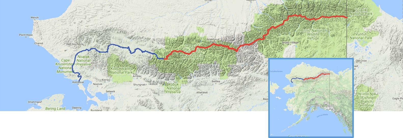
Route
If the weather is good, we will be set out at Joe River next to the Canadian border on June 7th by a small airplane. The most dangerous part about trekking the Brooks Range is crossing rivers. To minimize this risk, we will try to stay as close to the divide as possible, where the rivers are small. Especially in the first two weeks, snow covered passes might pose a problem, that is why we have several detours in mind. After approximately 24 days, we will reach the Dalton-Highway, the only road across the Range. From there we continue to the town on the Anaktuvuk Pass and then to the headwaters of Noatak River, which we will reach after approximately 46 days. At this point we will have covered around 1100 kilometers by foot. This makes an average of 24km per day - on hiking paths that would not be a big challenge but in the wet tundra we will need to hike 10-12 hours a day to reach this goal. For the final part of the journey we will float down almost the full length of the Noatak River (675km) in an inflatable raft and reach the ocean near the town of Kotzebue after some 60-65 days.
Pure Wilderness
Hiking 200km north of the Arctic Circle, we won’t find any paths and will only cross two small Inuit towns on the way. The area poses a lot of challenges: We have to move quickly in the soft and wet tundra, cross countless rivers and snow covered passes. The weather in the Brooks Range is extremely unpredictable: Temperatures range from freezing to 75 degrees and changes happen extremely quickly. Since the sun never sets, the daytime only has limited influence on the weather: In the open tundra we are not only exposed to storms, it is also possible to have the sun burn down on our tent during the whole night.Besides billions of mosquitos, the Brooks Range is home to many wild animals, including Grizzly- and Black Bears, Moose, Wolves and Lynx. For our own safety we will carry Pepper Spray and will never have food in or around our tent. However, we won't carry a firearm.

Food
Since we have to carry food for up to 12 days, the primary goal is easy: As light as possible. Per day and person we carry 4000-4500 calories, with which we should be able to more or less keep our body weight. To reach a density of around 4400 calories per kg, we have to eat a lot of fats - pure carbs only have a density of 4100 cal/kg.Breakfast: Milk powder, granola and oatmeal, to which we add almond and peanut butter.
During the day: Nuts, Power bars, chocolate, dried meat and fruits, crackers...
Dinner: dehydrated menus (warm), Ramen noodles

Minimal external support
Besides supplies in the town of Anaktuvuk Pass and at the Dalton Highway, we will cover the whole distance with only 2 supply flights. This means, we have to cover up to 250km with one load of our backpacks.