Hint: The icons on the map are clickable and with the button in the top right corner, the Map can be set to full screen
Subscribe to our Newsletter and don't miss any news!
News
Presentations03.02.2022 19:36
In the year 2022 we will give several presentations across Switzerland (in German). For more information please check out the German version of the Website.
Two Video-Clips online31.08.2018 09:38
After getting acclimatized in Switzerland again, we published two videos today: A short one with some impressions from our project as a whole and a longer one that gives you an idea how a daily routine of ours looked like. The second video contains a lot of German talking, if there is interest, we may add subtitles sometime. Let us know!
Pictures online08.08.2018 01:00
See menu on the left.
We reached the sea today!07.08.2018 05:27
We typed the message in German only because we only have a phone. Please use Google translate (sorry for the inconvinience):
Als wir heute morgen mit mulmigem Gefühl aus der Mündung des Noataks in den arktischen Ozean gerudert sind, war es geschafft: Wir haben die Brooks Range und damit ganz Alaska in Muskelkraft durchquert. 59 Tage und 20 Stunden benötigten wir von der kanadischen Grenze bis zur Westküste. Damit geht für uns ein Projekt zu ende, das uns in den letzten Monaten stark beschäftigt hatte und so ist zwar die Freude gross doch eigentlich war ja der Weg das Ziel und so sind wir auch durchaus etwas traurig, dass sich diese unglaubliche Reise nun dem Ende zuneigt. Das spezielle war allerdings, dass im Moment gar keine Emotionen aufkamen. Unsere Konzentration galt der Querung der Meerenge bei Kotzebue. Diese wurde erst sehr selten in Ruderbooten gemeistert und für uns barg sie viel Ungewissheit. Prompt frischte der Westwind auf, als wir weit weg von allen Ufern waren. Die rund 80cm hohen Wellen waren zwar für unser Boot kein Problem doch mussten wir am Ende aufkreuzen und kamen kaum mehr voran. Dies führte dazu, dass wir unser Camp aktuell noch 5 km ausserhalb von Kotzebue aufgeschlagen haben und in dem Sinne die Zivilisation noch nicht erreicht haben. Hier ein kleiner Rückblick auf den zweiten Teil des Projekts
Mühsames Gelände nach Anaktuvuk Pass
Nachdem wir das Inuit Dorf am Anaktuvuk Pass verlassen hatten, querten wir einige Flüsse, die von den Inuits als brandgefährlich erklärt wurden, problemlos. Danach erwartete uns sehr mühsames Gelände mit vielen flachen, sumpfigen Abschnitten und dichten Buschwäldern. Dies kam nicht unerwartet, war aber trotzdem keine Motivationsspritze. Darauf folgten die letzten Wandertage entlang des Alatna Rivers, die nicht nur wettermässig toll waren, sondern auch landschaftlich bestachen. Der glasklare Fluss bot unzählige wunderschöne Foto-Sujets. So waren wir beide etwas enttäuscht, als wir den Noatak River erreichten und dieser sich als braune Brühe durch eine sumpfige Landschaft schlängelte.
Noatak River: Nach der Flut
Wegen Problemen mit der Lieferung von unserem Equipment, das in Fairbanks liegen geblieben war, mussten wir am Noatak River unsere Essensrationen limitieren, was unangenehm war. Am Pingo Lake warteten wir, bis endlich der Motor des Wasserflugzeuges ertönte, das uns Nahrung, Boot und weiteres Equipment für den Fluss lieferte.
Der Noatak hatte diesen Frühling eine Jahrhundert-Flut erlebt und die Spuren waren gewaltig: Neben einem See, der sich komplett in den Fluss entleert hatte, waren die meisten Prallhänge extrem unterspült und wir konnten mehrfach beobachten, wie Teile davon in den Fluss kollabierten. Überall lagen Tundrabroken im Fluss und das ganze erschien stellenweise durchaus apokalyptisch. Dank des noch immer hohen Pegels kamen wir schneller voran als geplant: Ohne übermässige Anstrengung konnten wir täglich gegen 50km zurück legen. Der Pegel sank stetig (wir massen rund 5cm pro Nacht) und das Wasser klarte langsam auf. Ausserdem konnten wir die Sonnenstunden nachholen, die wir im ersten Teil des Projekts verpasst hatten: Meist war das Wetter warm und Regen war selten. Wir genossen die erholsame Fahrt und konnten sogar im Fluss schwimmen. Eines Tages erwachte der scheinbar tote Fluss zum Leben: An vielen Orten wimmelte es von riesigen Fischen. Der Lachszug hatte begonnen. Das Spektakel begleitete uns danach bis zur Mündung. Plötzlich hatte es auch mehr Tiere zu Land und Luft unterwegs: 15 Gryzzlies trafen wir entlang des Flusses und in der Luft wurden wir von Möwen, Falken, Adlern und riesigen Kranichen begleitet.
Der Fluss wird breit
Mit der Zeit wurden die Stromschnellen seltener und mit jedem Zufluss wälzte sich der Fluss noch Breiter richtung Meer. Der Fluss teilte sich nun in ein Labyrinth von Armen und Totläufen auf und so verpassten wir beinahe Noatak Dorf, das am rechten Rand eines gigantisch breiten Flussbetts steht. Nach einem kurzen Abstecher ins Dorf trafen wir bald auf die ersten Seehunde die dem Lachs aus dem Meer über 100km den Fluss hoch folgen. Die Strömung wurde nun langsamer und das Rudern etwas anstrengender. Gestärkt durch kiloweise Beeren und Fisch meisterten wir diese Herausforderung aber problemlos und so kam es, dass sich heute morgen die Fischer in der Meerenge von Kotzebue verwundert die Augen rieben: Ein kleines blaued Böötchen steuerte langsam rudernd aus dem Noatak Delta auf das Meer hinaus.
Hinweis: Bilder vom zweiten Teil unseres Projekts werden wir in den kommenden Tagen veröffentlichen.
Sorry für Schreibfehler, dieser Text wurde mit dem Smartphone getippt.
Back into the wild09.07.2018 20:23
Too tired of typing a full English translation on my phone, please use Google Translate on the German site. In short: We are heading out into the wild again. We expect to be offline until aug 9th.
Reached Anaktuvuk Pass, Pictures online09.07.2018 01:02
After 32 days and 903km we reached Anaktuvuk Pass today. We were able to upload some pictures too. For more info use google translate on the German text, We are tired of typing on our smartphone ;-)
24 hours to go. Last informations05.06.2018 18:40
The countdown is on: In 24 hours we will fly out to Fort Yukon and on June 7th in the morning we will fly from there to the starting point of our tour. far up north at the Canadian Border.
This means, we won't be able to use any conventional means of communication starting tomorrow. We will however update the live tracker on this website through our Satellite phone. Unfortunately we are not able to provide English translations of the messages. We recommend using Google Translate to read the messages.
Safely arrived in Fairbanks03.06.2018 03:26
We have safely arrived in Fairbanks. First, the immigration officer in Fairbanks thought it was a bit strange that we wanted to stay
80 days to hike but in the end, there was no problem getting past the border control.
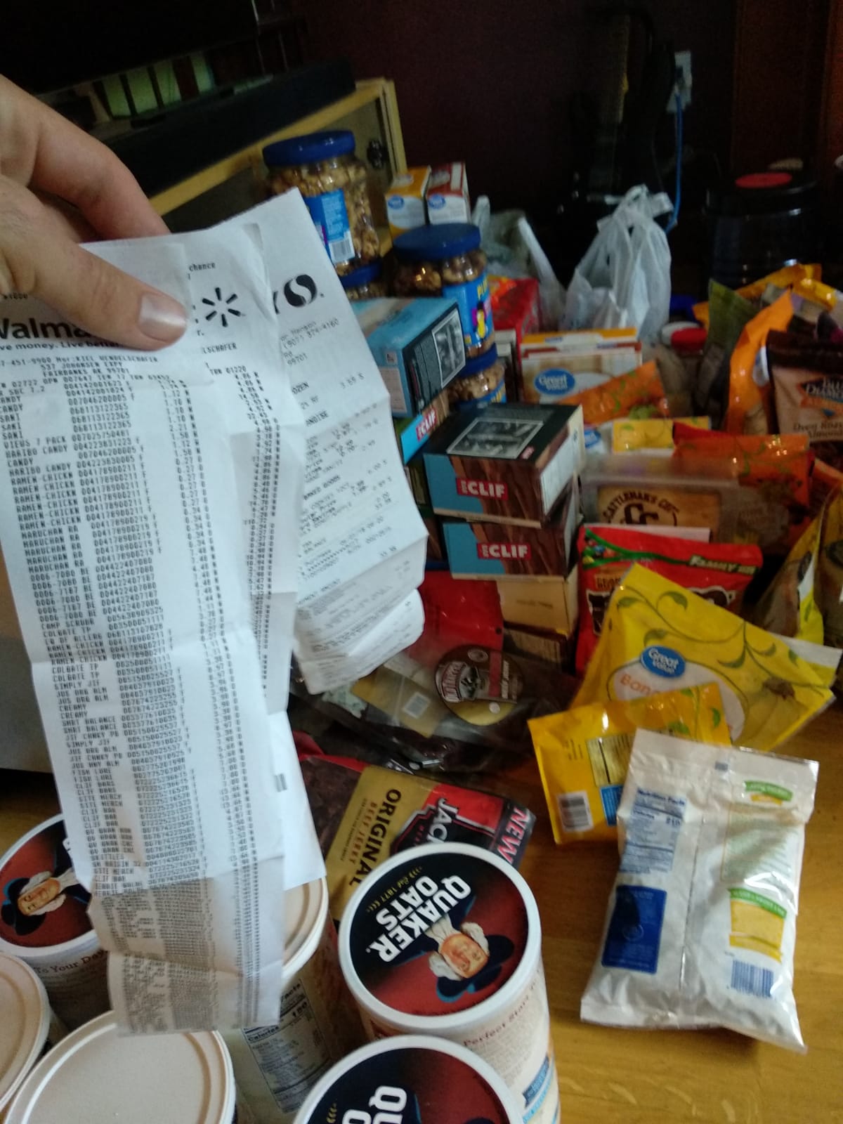
Long Receipts are daily business right now
The flight from Seattle to Fairbanks was very special: After taking off while it was getting dark at 21:30, the sun suddenly rose 2 hours into the flight and it stayed up until we landed around midnight. Here, the sun only sets for a short period of time each night and on our hike it will be constantly up for 2 months straight.
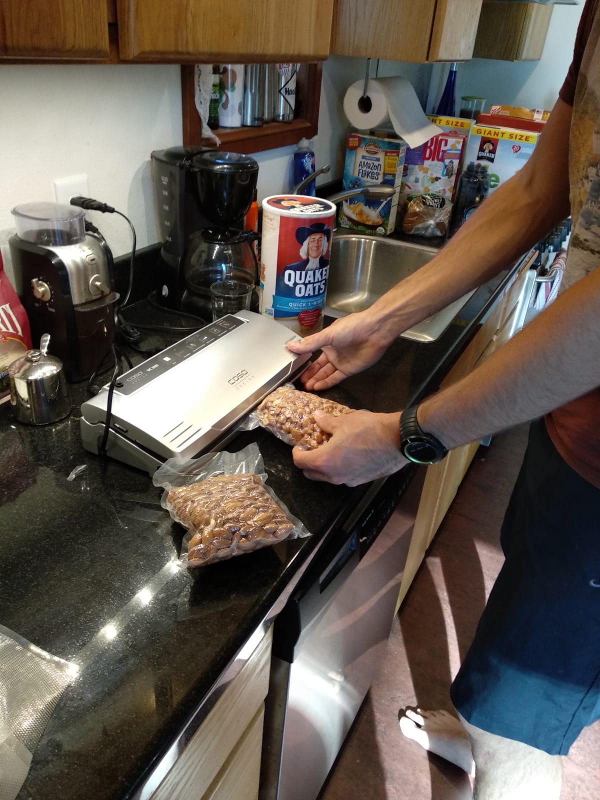
Manuel is vacuum-packing food
We have now already bought some 100kg more food and are in the process of packaging it, packing it and delivering the boxes to the right places so that we will have enough food during each stage of our hike.
Today we have taken a look at the canoe that we are going to use and gotten the sat phone. We rent these things here in Fairbanks.
By the way: We do not live in a hotel here. Evan, a friend of Manuel, is hosting us at his house. This eases all our preparation work a lot because we can use a kitchen and have enough room to lay out our things. (If you read this: Thanks Evan!)
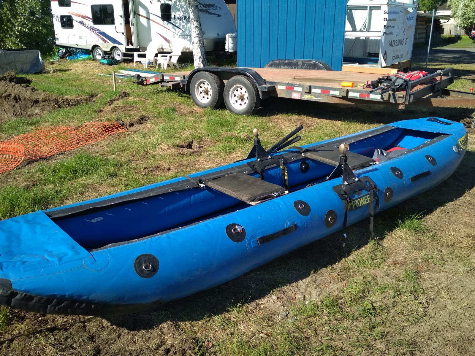
Our boat: a somewhat narrow raft which is stable in the water, allows heavy loads and is still somewhat fast
During the upcoming days we still need to organize a lot of minor things before we finally set out into the wild on Thursday.
Bears - A big risk?22.04.2018 18:26
In context with our tour, we are often questioned about the danger going out from bears and sometimes we see ourselves confronted with claims that are wrong. Here's our take on the subject:
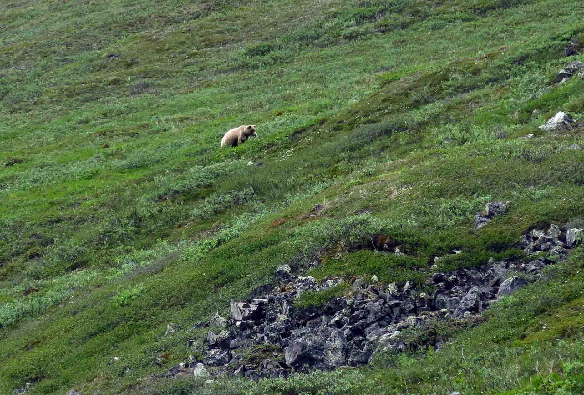
A grizzly in the open tundra of Brooks Range 2017. the animals are well visible and escape reliably as soon as they see a hiker.
The Brooks range is home to the "wildest" bears in the US. "Wildest" means that they are the least exposed to people or civilization. The animals are mostly grizzly and some black bear. The animals are smaller than in areas further south and the population density is relatively small with 2 Bears per 100 square kilometers. Nevertheless, encounters happen regularly: I (Manuel) have spent a total of about 30 days in the Brooks range and so far counted 3 encounters in the area including a bear with two cubs.
In Principle, Grizzlies fear people and flee as soon as they see you. Attacks usually happen when they feel threatened. Therefore bear encounters are dangerous when you surprise the animal. This happens mainly in thick scrub. Recommended measure is to constantly make noise when crossing such areas.
Like many other hikers in the Brooks range we will not carry a firearm because it is impractical and unnecessary. In the GOTA NP, there is only one known case of a deadly attack: in 1996 a hiker was killed by a bear in the thick bush along a river.
For possible encounters we will both carry a bear spray (310 ml Pepper Spray). They offer effective protection from bear attacks. However, they are no guarantee for safety. Since we mainly hike in open areas above the tree line, the chance of surprising a bear is rather low.
Undoubtedly the most important thing is that we do not store food near our tent and do not cook or eat in our camp. During the canoe section we will set up an electric fence around our camp to prevent bears from stealing our food.
By the way: Statistically, river crossings is far more dangerous than bears encounters. Therefore we have planned our route along the watershed to avoid large river crossings.
Reference: https://brooks-range.blog/2015/04/07/grizzly-bears-of-alaskas-brooks-range/
We are now on Facebook12.04.2018 19:05
Follow the Project on Facebook:
Support us!27.03.2018 19:22
A project of this size is not cheap. We both work hard to make are dream come true. If you like the project and want to support us, check out the subpage Support us!. Of course we have prepared small thank-you gifts for all supporters!
Besides this, we are also searching for companies, that are willing to support us with finances or equipment. More information is available on our subpage Sponsors
1000 Miles through the Wilderness09.02.2018 23:47
Starting on the 7th of june, we (Lukas Mathis and Manuel Meier) are going to try to cross the whole state of Alaska by foot and canoe. On this website you'll find all information about this project. Especially the Live Tracker is still in a trial phase - it is very well possible that it displays crazy stuff...